
If you have been following us on Facebook (Fitness Mama FB page), then you know that Christelyn had organized our very first Fitness Mama event! Our first gathering was a hike up Mission Peak in Fremont, CA. After weeks of preparation and lots of questions back and forth on our FB event page, the day had finally arrived.

When we first decided to make this our first event, there was not a lot of information online about the Mission Peak Hike. A lot of the info we had to go by were second hand accounts from friends who had previously hiked it before. We gathered a TON of information in order to make this event successful. I wanted to put all this information below out there so that if you guys decide to make this hike yourselves on your own, you have a little bit more information than what we initially had.
Bottom line is that it is a FUN hike to do with friends! I personally had a great time while getting an awesome workout in. Lots of laughs and good memories were had by all and by the accounts of it, we all were sore the next day.
But why were we so sore you ask?
The Mission Peak hike is no easy task, that's why!
There are several trails to take to get up to the summit of Mission Peak. The two most popular trails are the Hidden Valley/Peak Meadow Trails (better known as the Stanford Ave. Trail) and the Peak Trail (better known as the Ohlone College Trail). In our research, we learned that there are major differences in the trails that can be viewed as pros or cons depending on your mood or the kind of workout you want to have that day:
Stanford Ave. Trail:
-beautiful sweeping views of the Bay for almost the entire hike as this trail goes along the side of the peak that faces the Bay
-trail is steep and difficult BUT...
-this trail is shorter than the Ohlone Collage trail (5.5 miles roundtrip)
-can get crowded on the weekends/holidays
-very minimal parking (we were told that there were only a handful of designated parking spots and then you have to park in the surrounding neighborhoods if those were taken)
-little to no shade depending on time of day
Ohlone Collage Trail:
-this trail goes along the the side of the peak that faces Sunol Valley. Although beautiful, you will not see the Bay for most of the trail...mainly not until the last mile before the summit. This trail is very scenic with lots of green, rolling hills meeting the crisp blue skies.
-trail is longer than the Stanford Ave. trail (about a 10k roundtrip) BUT...
-this trail is not as steep the ENTIRE time. Do not be fooled though...there are some VERY steep parts.
-less crowded
-parking will never be a problem because you have the whole Ohlone college parking lot available to you. Parking is $2; day permits are available at the yellow boxes.
Weighing the pros and cons, it was decided that for this event, we would take the Ohlone College trail mainly because we didn't want to put our big group of people in a bad mood, looking for parking at the crack of dawn. We also wanted to make meeting up and finding everyone in our big group easy and we felt that a designated parking lot at the college would help do this. Our hike was planned on a Saturday during Labor Day weekend so we also did not want to compete with crowds on the trails for parking.
We all met up at 7am and completed introductions. This part was so exciting to me because I finally got to meet some of you guys in person! I finally got to meet one of our past Fit Mamas of the Week, Anne Marie. Putting faces to names and hearing real live voices that go with the faces was fun. I already knew I liked y'all but now I like y'all even MORE in person.
So then we played some music and did some stretches. Sunscreen was applied to all and we were off.
Btw, there was one port-o-potty here that was not on the parking lot but sort of near by, away from the trail. I recommend just going before you leave the house. I didn't see any water fountains. Bring water!
The Ohlone college trail is just a few steps from the parking lot. If you start early enough, the first mile or so is mostly shaded. The incline starts immediately and you will start sweating...immediately. :)
 |
| This was in front of the cave that everyone talks about. I thought it'd be bigger but it I can't even get into it standing up. You can find this on going up the Ohlone college trail on your left side within the first half mile. See what I mean by everything being fully shaded early on? On our way back down there was zero shade at this part=SUPER HOT. |

I'm looking at these above picture now and find it funny how we're all looking fresh and clean with tons of energy to take pictures with silly poses. It was a different story further along the trail. ;)

Even though we started off early in the day, it got HOT real QUICK. I wore a tank top which was good but I wish I had worn shorts instead of capri's so that I could stay cooler. There is about .75 mile area of the trail where it was shaded because of tree growth so that part of the trail was a chance to cool down, especially later on in the day going back down.

The above picture shows the shaded part of the trail. We are still going uphill but its sooo nice to have this shade on a hot day.
Most of the trail looked like this with no shade...


This above picture was taken at a point in the trail where our Ohlone college trail meets up with the Stanford Ave. trail. Both trails will go up the last part of the trail to the summit on the same road. There is also a bathroom here at this intersection. Not the cleanest bathroom with no plumbing so just be aware. I also did not see a water fountain either. There was one picnic table nearby too.

 |
| Ran into some friends from middle school/high school. #chipmanmiddleschool #cougarpride #westsidealameda #encinaljets |
 |
| So if this picture panned out to the right a bit more, you'd see the intersection of the trails and the little bathroom |
 |
| It's funny all the things you learn about one another on a three hour hike. These ladies started out as strangers to me but I feel like I found friends for life by the end of the hike. <3 |
 |
| Christelyn is the type of person who makes friends EVERYWHERE she goes and of course today was no different. We met Suzy along the trail and learned that she was training for half dome! She had done the Mission Peak hike every weekend (sometimes twice in one weekend) since like June! She'll be doing Half Dome in the Fall. Now I want to do Half Dome. So inspiring. |
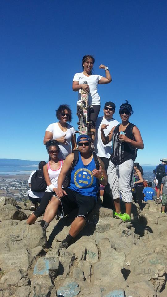
The last quarter mile was ROUGH. I was tired. I was hot. I was hungry. And the trail got steeper and steeper. But before I knew it I was there. That famous Mission Peak monument pole was right in front of us. We were so excited we took maybe 2 or 3 pictures. Ok maybe a couple hundred pictures but who's counting?
 |
| Remember how I said it could get crowded on the weekends? Along the trail, we ran into maybe a handful of people. But when we reached the summit there were a TON of people (which leads me to believe that everyone took the Stanford ave Trail). The girls are actually in line to take pictures by the monument pole behind them. There were so many people that there was a line! |


After a few snacks and a water break we headed back down after not too long because we were nearing midday and wanted to get off the trail before it got way too hot. We were warned of rattle snakes and mountain lions but the only animals we saw were cows. They were every where including ON the trail. There was one point where a mama cow had two little (like little little!) calves following her and anytime we took a step forward mama cow would holler and scream because she thought her babies were in danger. :( So beware of angry cows! We took a slight detour off the trail to move forward and to make mama cow feel at ease.
Going back down was almost as hard as going up because a declining trail and gravel are not a good mix. It was difficult to get secure footing at times. We took turns slipping and catching ourselves. Real hiking boots probably would've solved this problem.
Other tips and tricks:
-Bring water. It's a pain carrying water or carrying a backpack with water but it'll be a bigger pain if you pass out from dehydration. Don't underestimate this hike.
-Apply sunscreen before your hike then bring it with you to re-apply.
-Bring sunglasses and a visor or hat for extra sun protection.
-Pack some snacks to eat while you're enjoying the view from the top.
-If the sun is out, wear shorts and a tank top. Even if the sun is out and you're feeling chilly at the start...trust me...shorts and tank top is the way to go.
-Start early.
-Leave some baby wipes in the car. As I've mentioned, I didn't see any plumbing/running water/water fountains. Baby wipes were so useful to get cleaned up before driving home. You will be covered in dust from the trail.
Like I said, it took us a little less than three hours to complete this trail. This is with stopping to take pictures, using the bathroom, enjoying views periodically, and having a snack at the top. Oh and our little detour for the anxious mama cow probably added to our time too.


No comments:
Post a Comment